Geomaticians

January

New Software To Help With Schenectady Police Patrol Coverage, Give Officers Real-time Street Updates

New Software To Help With Schenectady Police Patrol Coverage, Give Officers Real-time Street Updates

An innovative software program will allow Schenectady police officers to track which streets have been patrolled in the city with real-time updates, the city announced on Tuesday. The new Patrolfinder software was produced by the Transfinder school bus-routing company in partnership with the Schenectady Police Department. The software, which will be deployed in all department ...
dailygazette.com
SkyFi Launches Satellite Imagery App

SkyFi Launches Satellite Imagery App

SkyFi believes that satellite imagery should be easily accessible and affordable for anyone to access. Today, the Austin, TX startup took a major step toward democratizing that data with the public launch of its mobile and web apps. The story so far: SkyFi built an entirely new app and interface for individuals to task satellites ...
payloadspace.com
Hexagon And Ness Provide Digital Maps For Czech Railways

Hexagon And Ness Provide Digital Maps For Czech Railways

Ness Czech will supply the Czech Railway Administration with a Digital Technical Railway Map (DTRM) with help from Hexagon’s Safety, Infrastructure and Geospatial division. The DTRM project has been underway since September 2022 and will be implemented by 2025. DTRM is a railway-specific geographic information system (GIS), that provides access to transport and technical infrastructure ...
b2bchief.com
Spacex Is Reducing Starlink's Impact On Astronom

Spacex Is Reducing Starlink’s Impact On Astronomy

NSF has outlined a new agreement it signed with SpaceX to protect ground-based astronomy covering the brightness of Starlink satellites, competing usage of radio bands, and finding ways to ensure Starlink’s orbital information is publicly available so astronomers can schedule observations around satellite locations. SpaceX has agreed to coordinate with impacted US radio astronomy facilities. ...
zdnet.com
China Launch Plans More Than 70 Launches In 202

China Launch Plans More Than 70 Launches In 2023

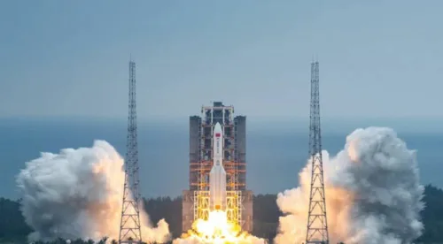
China’s state-owned and commercial space sector actors are planning a total of more than 70 launches across 2023 as the country’s space activities continue to expand. The China Aerospace Science and Technology Corporation (CASC), the country’s main space contractor and maker of the Long March rocket series, will again aim for more than 50 launches ...
spacenews.com
Esri India UC 2023 Marches Ahead To Transform Communities Through GIS

Esri India UC 2023 Marches Ahead To Transform Communities Through GIS

Esri India, India’s one of the leading Geographic Information System (GIS) solutions provider, is back with its flagship conference, Esri India User conference (UC) in-person this year. The theme of this year’s conference is ‘GIS — Transforming Communities’. The conference is scheduled to be held on January 18, 2023 in Delhi and on January 20, ...
geospatialworld.net

Synspective And Insight Terra Announce Space-enabled Data And Monitoring Solution For Mine Tailings Facilities

Synspective, a Tokyo based SAR (synthetic aperture radar) satellite data and solutions provider, and Insight Terra, a London based start-up providing a cloud based environmental and infrastructure risk management platform and solutions, have entered into a strategic partnership to deliver a new space enabled data and monitoring solution for the mining industry. The solution uses ...
realwire.com
IBGE Usa Plataforma Geográfica Interativa Para Monitoramento Da Coleta Do Censo 2022

IBGE Usa Plataforma Geográfica Interativa Para Monitoramento Da Coleta Do Censo 2022

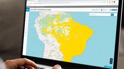
A Plataforma Geográfica Interativa (PGI), usada nas divulgações de produtos de geociências do IBGE, também está sendo utilizada para o acompanhamento dos recenseadores do Censo 2022. Com ela, o Instituto pode verificar a situação da coleta por cada setor em um mapa interativo. Na última sexta-feira (13), um seminário interno para os técnicos do IBGE ...
idest.com.br
Este Nuevo Mapa De Protección Civil Te Informa De Las Alertas Que Hay En Tu Zona En Tiempo Real Lluvias Torrenciales Y Más

Este Nuevo Mapa De Protección Civil Te Informa De Las Alertas Que Hay En Tu Zona En Tiempo Real: Lluvias Torrenciales Y Más

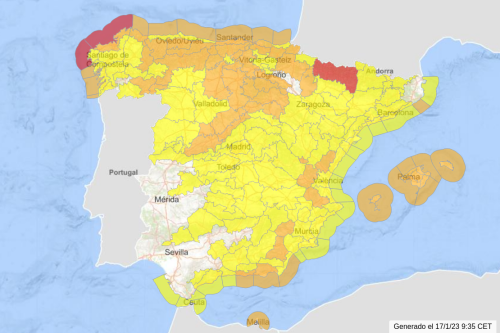
Esta nueva herramienta da visibilidad a la Red de Alerta Nacional (RAN) a través de un visor que se encuentra en una página web accesible desde un ordenador o un dispositivo móvil. Al momento de abrir la página se verá un mapa de toda España con todas las alertas que haya activas en ese momento ...
genbeta.com
“Geospatial Hackathon” Launched To Encourage Innovation And Start-ups In Indi

“Geospatial Hackathon” Launched To Encourage Innovation And Start-ups In India

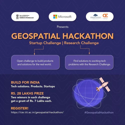
Dr. Jitendra Singh, the Union Minister for Science and Technology, launched the Geospatial Hackathon to encourage innovation and start-ups in India’s geospatial ecosystem. Speaking at the event in New Delhi, Dr. Singh stated that the hackathon’s goal was to encourage collaborations between the public and private geospatial sectors as well as to develop the nation’s ...
currentaffairs.adda247.com

European Space Agency Backs Geospatial Project To Protect Utilities

MGISS, a UK geospatial company, aims to understand how satellite imagery can identify areas where developments could disrupt gas and water supply. The Interruption Prevention Alert Service project will use satellite data and services to automatically detect changes to the built environment in order to prevent outages in critical utilities. The company argued that a ...
placetech.net
Lidar Survey Of New Zealand’s Taranaki Regio

Lidar Survey Of New Zealand’s Taranaki Region

A ground-breaking aerial LiDAR survey of Taranaki’s land surface has just been completed, opening up a wealth of valuable land-surface and elevation data for a wide range of uses. The dataset — collected in 2021 and two years in the making — will be used to generate high-definition 3D maps and models for environmental management ...
spatialsource.com.au

인천시, ‘시민참여형 디지털트윈 데이터댐 구축’ 완료

인천시(시장 유정복)는 2022년 주민참여예산 협치형 특정의제로 추진한 ‘시민참여형 디지털트윈 데이터댐 구축사업’을 완료했다고 11일 밝혔다. 시가 추진 중인 지리정보체계(GIS) 기반 디지털트윈 행정을 위해서는 물리적 환경이 변화하는 만큼 도시정보를 지속적으로 갱신·관리해야 한다. 그러나 코로나19 및 디지털전환 가속화 시대에 비대면·데이터 분야 일자리 수요는 늘어나고 있지만 관련 인력은 부족한 상황이다. 이에 시는 전국 최초로 도시기초데이터 수집을 위해 사회참여가 저조한 ...
joongdo.co.kr
제주도, 전국 최초 3차원 데이터 기반 스마트 소방 현장 대응 서비스 도

제주도, 전국 최초 3차원 데이터 기반 스마트 소방 현장 대응 서비스 도입

제주도는 지난 10일 각종 재난 현장 출동 시 신속한 대응과 소방대원 안전사고 예방을 위한 ‘현실 세계 대응 체계’를 구축하는 ‘3차원 데이터 기반 스마트 소방 현장 예방 대응 서비스’ 완료보고회를 개최했다. 이번 보고회에서는 화재 등 재난 발생 시 시설물 정보 부재와 기형적 건물 구조로 소방대원의 경험과 도면에 의존해야 하는 현장 대응의 어려움을 해소하고, 현실 세계를 반영한 ...
boannews.com

Nowość O Pomiarach Obiektów Naturalnych I Sztucznych

Nakładem Oficyny Wydawniczej Politechniki Wrocławskiej ukazała się książka pt. „Pomiary geometrii w ochronie środowiska, energetyce i górnictwie”. Jej autorem jest dr inż. Tadeusz Głowacki, adiunkt w Katedrze Geodezji i Geoinformatyki PWr. Książka poświęcona jest geodezji: nauce o pomiarach Ziemi, a także obiektów powstałych na jej powierzchni i ich wzajemnym przestrzennym rozmieszczeniu. Uwzględniane są obiekty naturalne ...
geoforum.pl

Northstar Signe Un Partenariat Avec Une Entreprise Japonaise

L’entreprise montréalaise NorthStar Ciel & Terre, a annoncé mercredi avoir signé une entente avec l’entreprise japonaise Axelspace, dans le but de fournir les tout premiers services de suivi d’objets spatiaux (SSA) combinés sol/espace. Les services de surveillance par satellites proposés par NorthStar permettent notamment à ces clients d’éviter les collisions dans l’espace. «Le développement durable ...
journaldequebec.com

El Gemelo Digital De Galicia Permitirá La Gestión Y Planificación Inteligente Del Territorio

La Agencia para la Modernización Tecnológica de Galicia, junto con la Agencia Gallega de Desarrollo Rural y el Instituto de Estudios del Territorio desarrollarán la reproducción virtual de Galicia en forma de gemelo digital. Se trata de una iniciativa promovida por la Xunta de Galicia que forma parte de los 11 proyectos emblemáticos de transformación ...
esmartcity.es

Señalan Al Control Geoespacial Como El Culpable De Que Más Del 20% De Los Agricultores Sorianos No Haya Recibido La Liquidación De La Pac 2022

La Asociación Agraria de Jóvenes Agricultores (ASAJA) de Soria ha emitido un comunicado solicitando celeridad a la administración en el pago de la liquidación pendiente de la PAC 2022 “para muchos agricultores de nuestra provincia que no la recibieron en los últimos días del año pasado”, señalan advirtiendo que “más de un 20 por ciento ...
elaltojalon.es
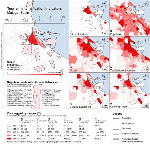
Proponen Una Nueva Metodología Para Identificar Y Medir La Intensidad Del Turismo En La Costa Mediterránea

Proponen Una Nueva Metodología Para Identificar Y Medir La Intensidad Del Turismo En La Costa Mediterránea

Una reciente investigación desarrolla por la Escuela Técnica Superior de Arquitectura de la Universidad de Málaga propone una nueva metodología que identifica el patrón de intensidad del turismo en la costa mediterránea, en concreto en las ciudades de Málaga y Valencia. Frente a otros estudios previos, basados en variables cuantitativas, este trabajo aborda también variables ...
uma.es

A New Tool Helps Map Out Where To Develop Clean Energy Infrastructure

The Geospatial Energy Mapper (GEM) is a comprehensive, interactive online mapping tool that can help identify areas across the country that are suitable for wind, solar and more. First publicly launched in 2013 as the Energy Zones Mapping Tool (EZMT), GEM has been redesigned, rebranded and reengineered. GEM is hosted by the U.S. Department of ...
sciencedaily.com

Grafcan Produce Nuevas Ortofotos Con Técnicas De Inteligencia Artificial

La Consejería de Transición Ecológica, Lucha contra el Cambio Climático y Planificación Territorial del Gobierno de Canarias, a través de la empresa pública Cartográfica de Canarias (Grafcan), ha actualizado el servicio de ortofotos de la Infraestructura de Datos Espaciales de Canarias (IDECanarias) correspondiente a 2022 con imágenes de mayor resolución aumentadas con técnicas de inteligencia ...
gobiernodecanarias.org

PMA Avança Na Criação Do Sistema De Dados Espaciais De Aracaju

Lançado em outubro de 2021, o Projeto de Infraestrutura de Dados Espaciais (IDE) da capital sergipana, desenvolvido pela Prefeitura de Aracaju, através da Secretaria Municipal da Fazenda (Semfaz), entra em nova fase, em 2023, e em breve um novo sistema será disponibilizado para que toda a população tenha acesso a informações detalhadas sobre a cidade. ...
faxaju.com.br

برآورد سطح زیرکشت ۳ محصول استراتژیک با فناوری فضایی

در راستای اجرای تفاهم‌نامه بین وزارت ارتباطات و فناوری اطلاعات و وزارت جهاد کشاورزی با عنوان “توسعه کشاورزی هوشمند با بهره‌گیری از فناوری‌های نوین ارتباطات و فناوری اطلاعات”، برآورد سطح زیرکشت محصولات راهبردی گندم-جو و برنج آغاز شد. اجرای این پروژه به مرکز تحقیقات پژوهشگاه فضایی ایران ابلاغ شده و در نظر است ضمن توانمندسازی ...
isna.ir

Progetto CARG Di ISPRA: Nuove Risorse A Disposizione Per La Carta Geologica Ufficiale Del Territorio Italiano

Con la Legge di Bilancio 2023 sono state assegnate risorse, al Dipartimento per il servizio geologico d’Italia dell’Istituto superiore per la protezione e la ricerca ambientale (ISPRA), per il completamento della Carta geologica d’Italia (CARG). In particolare, è autorizzata a favore del medesimo Istituto la spesa di 6 milioni di euro per ciascuno degli anni ...
ingenio-web.it

KMC Starts GIS Mapping Of Ponds Within Its Jurisdiction

The Kolkata Municipal Corporation (KMC) is conducting Geographical Information System (GIS) mapping of all the ponds within its jurisdiction while it is also identifying lands which were previously water-bodies. The civic body presently is working on a war footing to protect ponds in the city, which are fast filling up for real estate development purposes ...
millenniumpost.in

U.K.’S Highly Touted Space Launch Fails To Reach Orbit Due To An ‘Anomaly’

The rocket was set to make history, carrying satellites on what would be the first-ever orbital launch from the U.K. on Monday night. But Virgin Orbit says its LauncherOne rocket “experienced an anomaly” just before it could deliver its payload, and the craft was lost. Virgin Orbit says it’s reviewing the flight data to determine ...
ideastream.org

Geospatial World Forum Returns To Rotterdam With Industry-advancing Agenda

This year marks the 14th edition of Geospatial World Forum (GWF), a platform for global geospatial community, attended by senior executives representing public policies, national geospatial and space agencies, large business enterprise users, commercial companies, and professional and academic institutions from 75+ countries. After three consecutive years in Amsterdam, the event returns to Rotterdam, to ...
geospatialworld.net

Artificial Intelligence Deep Learning Model For Mapping Wetlands Yields 94% Accuracy

Chesapeake Conservancy’s data science team developed an artificial intelligence deep learning model for mapping wetlands, which resulted in 94% accuracy. Supported by EPRI, an independent, non-profit energy research and development institute; Lincoln Electric System; and the Grayce B. Kerr Fund, Inc., this method for wetland mapping could deliver important outcomes for protecting and conserving wetlands. ...
directionsmag.com

Punjab Launching New Land Record System

The Punjab government is starting a new land record system, but the revenue record of 460 mouzas (villages) in the district of Rawalpindi is still incomplete. Upon this, the Board of Revenue (BoR) has written a letter to the deputy commissioner to complete the scanning of ‘Massavi’ (details of land ownership) by January 9, as ...
dawn.com

Previsico Leverages Next-gen Satellite To Enhance Flood Alerts

Live flood alert InsurTech platform Previsico has partnered with the new €4.3bn Meteosat Third Generation satellite system. This new system will allow Previsico to be more accurate and timelier with flood warnings, providing insurers and property owners with more time to mitigate flood impacts. The first satellite of the new generation was launched on 13 ...
fintech.global