Geomaticians

Hydrology

Yeraltı Sularının Kullanılması Nedeniyle…

Gümüşhane Üniversitesi Rektörü Prof. Dr. Halil İbrahim Zeybek, Mühendislik ve Doğa Bilimleri Fakültesi Harita Mühendisliği Bölüm Başkanı Doç. Dr. Sefa Yalvaç ile Mühendislik ve Doğa Bilimleri Fakültesi Jeoloji Mühendisliği Bölümü Uygulamalı Jeoloji Kürsüsü Öğretim Üyesi Doç. Dr. Selçuk Alemdağ, zemin çökmelerinin güncel jeodezik tekniklerle izlenmesi ve olası nedenlerinin araştırılmasına yönelik bilimsel çalışma başlattı. Çalışmalar kapsamında ...
torbaliguncel.com

México Lanza Plataforma Para Monitorear El Uso Del Agua En La Minería

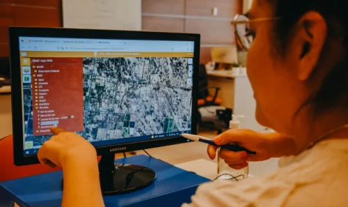
El Gobierno mexicano lanzó este martes el Sistema de Información Geográfica (SIG), denominado “Agua y Minería”, con el que planea mejorar el uso del agua y monitorear la relación que tiene la actividad minera con los acuíferos de México. La nueva plataforma pública fue desarrollada por el IMTA y recupera información del Registro Público de ...
swissinfo.ch

Mysterious White Clouds Keep Popping Up Near The Bahamas, And No One Knows Why

The perplexing patches of light-colored ocean are sometimes noticed in other oceans and lakes worldwide, but in the Bahamas, they pop up more often than usual. Direct sampling of the cloudy waters suggests they contain high concentrations of carbonate-rich particles. Much of the Bahama archipelago sits on a submerged platform of carbonate known as the ...
sciencealert.com

Artificial Intelligence Deep Learning Model For Mapping Wetlands Yields 94% Accuracy

Chesapeake Conservancy’s data science team developed an artificial intelligence deep learning model for mapping wetlands, which resulted in 94% accuracy. Supported by EPRI, an independent, non-profit energy research and development institute; Lincoln Electric System; and the Grayce B. Kerr Fund, Inc., this method for wetland mapping could deliver important outcomes for protecting and conserving wetlands. ...
directionsmag.com

Intermap Announces New Government Project In Malaysia

Intermap Technologies, a global leader in 3D geospatial data and intelligence solutions, today announced it was awarded another government contract in Malaysia to provide 3D elevation data to help assess the causes of pollution in the Skudai River for the State of Johor Baru. The Johor Water Management Authority in West Malaysia is conducting analysis ...
financialpost.com
Using Satellites To Track Groundwater Depletion In Californi

Using Satellites To Track Groundwater Depletion In California

Combined with California’s large population, long history of drought and tendency to be battered by nearly every form of climate change, massive groundwater pumping is aggravating water scarcity, said Xuechen Yang, lead author of the case study and a graduate student in earth sciences at The Ohio State University. “By 2025, more than 5 billion ...
scienceblog.com

NASA Has Lost Contact With A Hurricane-watching Satellite

NASA is working to reestablish contact with one of the eight spacecraft that make up its Cyclone Global Navigation Satellite System (CYGNSS) constellation, which monitors hurricanes. CYGNSS is the first space-based system to collect frequent measurements of wind speeds from the ocean’s surface near the eye of storms such as tropical cyclones, typhoons and hurricanes. ...
space.com
Predicting The Future Landscape Of A River

Predicting The Future Landscape Of A River

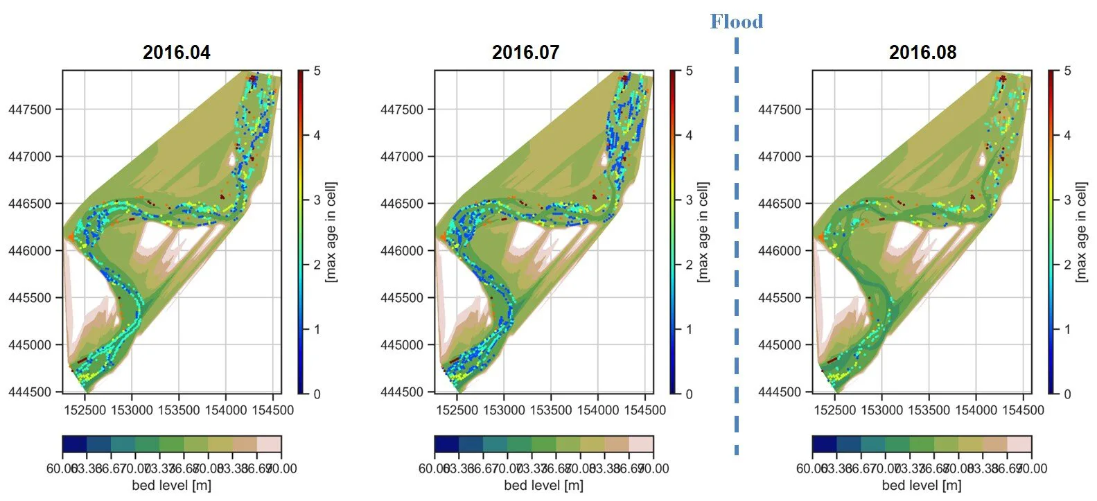
A joint research team, including scientists from Korea Institute of Civil Engineering and Building Technology (KICT) and Deltares of the Netherlands, has conducted research on prediction of the future changes in river landscapes using an eco-morphodynamic model applied to an actual river. According to the study result, the vegetation cover will increase continuously until 2031, ...
phys.org
Ferramenta Desenvolvida Pelo Cemaden E O Programa Servir-amazonia Prevê Inundações Com Antecedência

Ferramenta Desenvolvida Pelo Cemaden E O Programa Servir-amazonia Prevê Inundações Com Antecedência

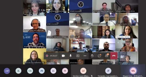
Com a cooperação técnica firmada há um ano entre o Cemaden/MCTI, a Aliança Bioversity-CIAT e o Programa Servir-Amazonia (do Programa Servir-Global), as instituições vêm desenvolvendo os serviços de informação para o monitoramento hidrometeorológico, modelagem de inundações e deslizamentos de terra e lançaram a ferramenta Hydroview para previsão de inundações no Brasil. O lançamento do serviço ...
conexaoto.com.br

Dissesto Idrogeologico: Nuovi Modelli Prevedono L’impatto Delle Colate

Un team di ricercatori dell’ENEA ha sviluppato un nuovo approccio per prevedere l’area di propagazione e l’intensità delle colate rapide, un particolare tipo di frane veloci altamente distruttivo, e sta testando nuove metodologie per stimarne le soglie di innesco in base al contenuto di acqua dei terreni di copertura. Le innovazioni volte al la produzione ...
corrierenazionale.it

The First Complete Picture Of Arctic Sea Ice Freeze-thaw Cycle Highlights Sea Ice Response To Climate Change

Years of research show that climate change signals are amplified in the Arctic, and that sea ice in this region is sensitive to increases in Arctic warming. Sea ice greatly modifies the exchanges of heat, momentum and mass between the atmosphere and the ocean. So, the timings of the sea ice melt and freeze onsets, ...
eurekalert.org

¡Con Tecnología De La NASA! Plataforma De Senamhi Permitirá Mejorar Pronóstico De Inundaciones

El Servicio Nacional de Meteorología e Hidrología del Perú (Senamhi) anunció el lanzamiento de Senamhi GEOGloWS, una plataforma que cuenta con tecnología de la Administración Nacional de Aeronáutica y del Espacio (NASA). Con los datos obtenidos se espera optimizar el pronóstico de inundaciones a nivel nacional. Este nuevo sistema ha sido personalizado con las condiciones ...
larepublica.pe

Rutgers Researcher Creates Algorithms To Predict Arsenic Contamination In Private Wells In New Jersey

“New Jersey has many naturally occurring arsenic sources, which can elevate the arsenic concentration in groundwater,” said Subhasis Giri, an assistant research professor in the Department of Ecology, Evolution and Natural Resources and lead author of the study published in the journal Science of the Total Environment. “Our work contributes to the understanding of this ...
newswise.com

Harán Un Relevamiento Aéreo De La Cuenca Del Arroyo Cululú

El Estado provincial llamó a licitación para realizar la “Monumentación de puntos fijos y Relevamiento Planialtimétrico Aéreo con Tecnología Lidar y Fotogramétrica de Sistemas Hidrológicos de la Provincia de Santa Fe – Etapa II – Cuenca del Arroyo Cululú Provincia de Santa Fe”, en un área que abarca 845 mil hectáreas de los departamentos Castellanos ...
rafaelanoticias.com

Earth’s Many New Lakes

The number of lakes on our planet has increased substantially in recent decades, according to a unique global survey of 3.4 million lakes that the University of Copenhagen has taken part in. There has been a particular increase in the number of small lakes, which unfortunately, emit large amounts of greenhouse gas. The development is ...
sciencedaily.com
Gestión Hídrica Presentan Nueva Información Satelital Sobre Cuencas, Ramos Y Derechos De Rieg

Gestión Hídrica: Presentan Nueva Información Satelital Sobre Cuencas, Ramos Y Derechos De Riego

El Departamento de Hidráulica, junto a la Unidad de Infraestructura de Datos Espaciales (UNIDE) -dependiente de la Secretaría de la Gestión Pública, Ministerio de Hacienda y Finanzas- presentaron la nueva información satelital disponible al público sobre cuencas, ramos y derechos de riego clasificados por su uso (poblacional, agrícola e industrial, entre otros). A través del ...
sisanjuan.gob.ar

Using Sentinel-2 Data For Seawater Quality Monitoring

In an article published in the journal Remote Sensing, the researchers used Sentinel-2/Multispectral Instrument (MSI) imagery data to a calibrated ocean chlorophyll 2-band (OC-2) model to retrieve chlorophyll-a (chl-a) concentration in the Ha Long bay from 2019 to 2021. Using Sentinel-2 MSI photos on the Google Earth Engine (GEE) platform, this study examines the anthropogenic ...
azooptics.com
Scientists Map Hidden Waterways Under Naples

Scientists Map Hidden Waterways Under Naples

Avast network of waterways lies hidden under Naples, Italy, including aqueducts that were built when the ancient Greeks colonized the area. “They are waterways or aqueducts that were constructed during that period and also during Roman times,” says Nick De Pace. “There are also streams and other waterways that were developed over time to guide ...
yaleclimateconnections.org
Climate Change Is Making Lakes Less Blue

Climate Change Is Making Lakes Less Blue

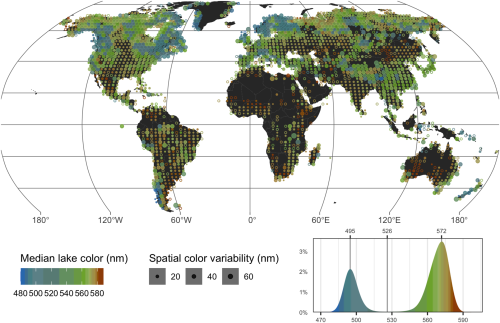
If global warming persists, blue lakes worldwide are at risk of turning green-brown, according to a new study which presents the first global inventory of lake color. Shifts in lake water color can indicate a loss of ecosystem health. While substances such as algae and sediments can affect the color of lakes, the new study ...
eurekalert.org
Researchers Map Streamflow Alterations To Gauge Human Impact On Ecosystems

Researchers Map Streamflow Alterations To Gauge Human Impact On Ecosystems

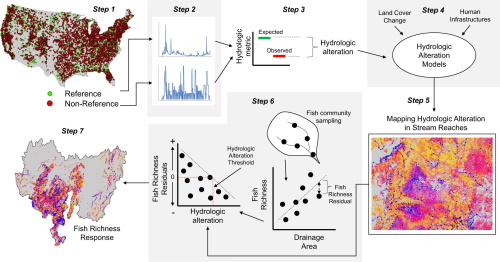
Altering streamflow can endanger the ecosystems that rely on it, but researchers have lacked data on how human infrastructure has impacted streamflow in the U.S. Now, a study involving a Colorado State University researcher has mapped streamflow alterations across the continental U.S., providing a wealth of data for determining societal impacts on ecosystems. Up to ...
phys.org
Presentan Un Mapa Online Que Identifica Los Humedales De La Argentina

Presentan Un Mapa Online Que Identifica Los Humedales De La Argentina

Con la participación de más de 30 especialistas del INTA de todo el país, se generó un mapa nacional de humedales. Se trata de una herramienta técnica, con información actualizada y precisa, disponible en una plataforma online, de acceso libre y gratuito. Un desarrollo clave para la toma de decisiones en relación con estos socio-agroecosistemas. ...
intainforma.inta.gob.ar

NIWA Uses Satellite Images To Track Health Of New Zealand’s Coastal Waters

For the first time, NIWA has used satellite images to monitor the health of coastal waters around Aotearoa by tracking levels of suspended sediment in those waters. Satellite data has already been used to monitor algal blooms, oil spills and water temperature, NIWA said. Now, NIWA has analysed images from NASA’s Aqua MODIS satellite which ...
rnz.co.nz

Projeto Inovador Visa Combater Perdas De Água Em Capivari

Um projeto inovador com o objetivo de combater as perdas de água e melhorar a gestão do sistema de abastecimento em Capivari (SP) será implantado pela Agência das Bacias PCJ a partir de setembro. A medida segue deliberação dos Comitês PCJ (Bacias dos Rios Piracicaba, Capivari e Jundiaí), por iniciativa das Câmaras Técnicas de Saneamento ...
portalhortolandia.com.br

بارگذاری اطلاعات مکانمند شرکت آب بر روی پلاک‌های آبی هوشمند در اصفهان

مدیرعامل سازمان فناوری اطلاعات و ارتباطات شهرداری اصفهان از بارگذاری اطلاعات مکانمند شرکت آب بر روی پلاک‌های آبی هوشمند مناطق 8 و 12 شهرداری اصفهان خبر داد. وی تصریح کرد: طی جلسات کارشناسی که با حضور نمایندگان شهرداری و شرکت آب و فاضلاب استان اصفهان برگزار شد، درخصوص توسعه زیرساخت اطلاعات مکانی یکپارچه در قالب ...
rokna.net

Dall’elaborazione Statistica Di Immagini Sentinel-2 Al Monitoraggio Quantitativo Della Siccità: Primi Risultati Di ISPRA

Nell’ambito della Convenzione Operativa ASI-ISPRA “Habitat Mapping” (2017-2021), l’Area Idrologia, Idrodinamica e Idromorfologia di ISPRA, in collaborazione con il Politecnico di Milano, ha sviluppato e implementato degli algoritmi e delle procedure per la mappatura e la classificazione degli alvei fluviali nelle tre componenti costitutive – superficie bagnata, vegetazione, sedimenti – a partire dalle immagini di ...
isprambiente.gov.it
Calif. Launches Mapping Tool For Groundwater Sustainability Projects

Calif. Launches Mapping Tool For Groundwater Sustainability Projects

A new web-based tool developed by the California Department of Water Resources (DWR) will allow the public to explore thousands of groundwater projects across California to get a better understanding of one of the state’s most critical water supply resources. The California Groundwater Projects Tool is an interactive mapping tool that allows users to explore ...
waterworld.com
New Map Tool Available For Looking Up Water Main Breaks And Outages

New Map Tool Available For Looking Up Water Main Breaks And Outages

Boulder community members can now look up water service outages in the city of Boulder using a new Water Outages Map. The map is designed to improve customer service by enabling community members to quickly determine whether water service disruptions have been confirmed by the city and if outages have been resolved. It displays planned ...
bouldercolorado.gov
US-European Satellite Will Make World’s First Global Freshwater Survey

US-European Satellite Will Make World’s First Global Freshwater Survey

Water is life, but for all its importance, humanity has a surprisingly limited view of Earth’s freshwater bodies. Researchers have reliable water level measurements for only a few thousand lakes around the world, and little to no data on some of the planet’s important river systems. The upcoming Surface Water and Ocean Topography (SWOT) satellite ...
jpl.nasa.gov
OGC Calling For Participation In Its Water Quality Interoperability Experiment

OGC Calling For Participation In Its Water Quality Interoperability Experiment

The Open Geospatial Consortium (OGC) has released a Call for Participation (CFP) to solicit proposals for the OGC Water Quality Interoperability Experiment (WQ IE), which will advance the development of the WaterML 2.0 suite of standards in the area of water quality data. Proposal submissions are due by September 13, 2022.
directionsmag.com