Geomaticians

LULC

Scientists Use Satellite Images To Study The Degradation Of Rangelands In Tanzania

Scientists Use Satellite Images To Study The Degradation Of Rangelands In Tanzania

As part of the study, published in Scientific Reports, scientists combined field data on vegetation with high-resolution satellite images gathered over the last two decades to identify the drivers of degradation within the Northern Tanzanian rangelands. The study found evidence that sites that are currently degraded are more sensitive to environmental shocks such as drought, ...
york.ac.uk
A New Vegetation Mapping Of Qinghai-Tibet Plateau Based On Terrain-Climate-Remote Sensing

A New Vegetation Mapping Of Qinghai-Tibet Plateau Based On Terrain-Climate-Remote Sensing

The Qinghai-Tibet Plateau is the roof of the world and the water tower of Asia. It is known as the third pole of the Earth. It is an important ecological security barrier, a strategic resource reserve base, and an important area for preservation of Chinese culture. Obtaining high-precision vegetation types and distribution data is a ...
phys.org
Wasserknappheit In Iran Ist Hausgemacht

Wasserknappheit In Iran Ist Hausgemacht

Forschende des Deutschen GeoForschungsZentrums GFZ haben zusammen mit Kolleg:innen der Universität Stuttgart und des Karlsruher Instituts für Technologie KIT die Entwicklung der letzten zwanzig Jahre für den gesamten Iran nachgezeichnet. Die Studie erschien kürzlich in der Fachzeitschrift Scientific Reports. Das Team nutzte dafür ausschließlich global verfügbare Datensätze, u.a. MODIS-Satellitenzeitreihendaten, Daten der GRACE/-FO-Satellitenmissionen und ERA5-Reanalyse-Klimadaten. Für ...
gfz-potsdam.de

Esri Releases New App To Easily View And Analyze Global Land-Cover Changes

Esri, the global leader in mapping and location intelligence, has now released a new online application, Sentinel-2 Land Cover Explorer. The app is structured around a web-based version of its own high-resolution global land-cover map, derived from European Space Agency (ESA) Sentinel-2 satellite imagery. The app is easy to access and leverages the same geographic ...
geospatialworld.net
Midwest Farmers Using Cover Crops Take Small Yield Hit

Midwest Farmers Using Cover Crops Take Small Yield Hit

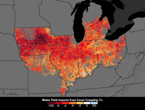
Most farm fields in the U.S. Midwest lay bare over the winter. From the time of corn and soybean harvests—sometime between September and December—until the planting season in spring, valuable topsoil is often unprotected. Wind, snowmelt, and rain can remove topsoil and nutrients from fields and carry them into the Mississippi River, where, instead of ...
earthobservatory.nasa.gov

New Horizon Europe Project ‘Evoland’ Sets Off

A consortium under the lead of VITO officially launched the new Horizon Europe project EvoLand in Leuven (Belgium). EvoLand will develop and test new and innovative methods and algorithms and implement a bundle of candidate Copernicus Land Monitoring Service prototypes. This will be realised by integrating novel EO and in-situ data with the latest Machine ...
geospatialworld.net

Señalan Al Control Geoespacial Como El Culpable De Que Más Del 20% De Los Agricultores Sorianos No Haya Recibido La Liquidación De La Pac 2022

La Asociación Agraria de Jóvenes Agricultores (ASAJA) de Soria ha emitido un comunicado solicitando celeridad a la administración en el pago de la liquidación pendiente de la PAC 2022 “para muchos agricultores de nuestra provincia que no la recibieron en los últimos días del año pasado”, señalan advirtiendo que “más de un 20 por ciento ...
elaltojalon.es

برآورد سطح زیرکشت ۳ محصول استراتژیک با فناوری فضایی

در راستای اجرای تفاهم‌نامه بین وزارت ارتباطات و فناوری اطلاعات و وزارت جهاد کشاورزی با عنوان “توسعه کشاورزی هوشمند با بهره‌گیری از فناوری‌های نوین ارتباطات و فناوری اطلاعات”، برآورد سطح زیرکشت محصولات راهبردی گندم-جو و برنج آغاز شد. اجرای این پروژه به مرکز تحقیقات پژوهشگاه فضایی ایران ابلاغ شده و در نظر است ضمن توانمندسازی ...
isna.ir
UV Apoya Al Municipio De Jilotepec Con Estudios Cartográfico

UV Apoya Al Municipio De Jilotepec Con Estudios Cartográficos

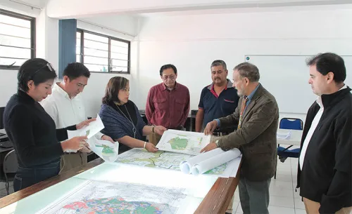
A solicitud de las autoridades del Ayuntamiento de Jilotepec, académicos y estudiantes de la Universidad Veracruzana (UV) desarrollan el proyecto “Estudio cartográfico de Jilotepec”, conformado por un sistema de información geográfica y un atlas municipal, en el que se analiza la principal problemática que lo afecta y se proponen, con base en la sustentabilidad, probables ...
uv.mx

إعادة تأهيل المراعي الطبيعية المتدهورة باستخدام طائرات الدرونز

وقع المركز الوطني لتنمية الغطاء النباتي ومكافحة التصحر، عقدا مع تحالف المكتب الإقليمي للاتحاد العالمي لحماية الطبيعة في الشرق الأوسط وشمال آسيا (IUCN) وشركة تلاد البيئة التجارية؛ لتنفيذ مشروعي دراسة مواقع إعادة تأهيل المراعي المتدهورة، وتحديد الحمولة الرعوية في عدد من المناطق المستهدفة. وأوضح المركز أن المشروع الأول يستهدف دراسة مواقع تنفيذ مشاريع إعادة تأهيل ...
ajil.news

Illinois Farmers Planting More Cover Crops

That’s according to new University of Illinois research showing cover crop adoption reached 7.2% in 2021, up from just 1.8% a decade prior. The finding is the result of sophisticated satellite-based remote sensing efforts that accurately detected cover crops across 140 million acres of cropland and tracked their expansion over 20 years. “We analyzed the ...
thetelegraph.com

Gugik Prezentuje Mapę Pokrycia Terenu Polski

Centralny zasób geodezyjny i kartograficzny wzbogacił się właśnie o mapę pokrycia terenu Polski w skali 1:500 000. Głównym źródłem danych dla tej mapy były bazy: Państwowego rejestru granic (PRG), Państwowego rejestru nazw geograficznych (PRNG), Bazy danych obiektów topograficznych (BDOT10k), Bazy danych obiektów ogólnogeograficznych (BDOO), urzędowego wykazu polskich nazw geograficznych świata, Generalnej Dyrekcji Dróg Krajowych i ...
geoforum.pl
Pampa Sul-americano Perde Um Quinto Da Vegetação Campestre Entre 1985 E 2021

Pampa Sul-americano Perde Um Quinto Da Vegetação Campestre Entre 1985 E 2021

A análise de imagens de satélite captadas entre 1985 e 2021 por uma rede colaborativa de especialistas da Argentina, Brasil e Uruguai, sob coordenação do MapBiomas, mostra que o Pampa Sul-Americano perdeu 20% de sua vegetação campestre no período, incluindo 8,7 milhões de hectares de campos nativos e 260 mil hectares de florestas. Os dados ...
extraclasse.org.br
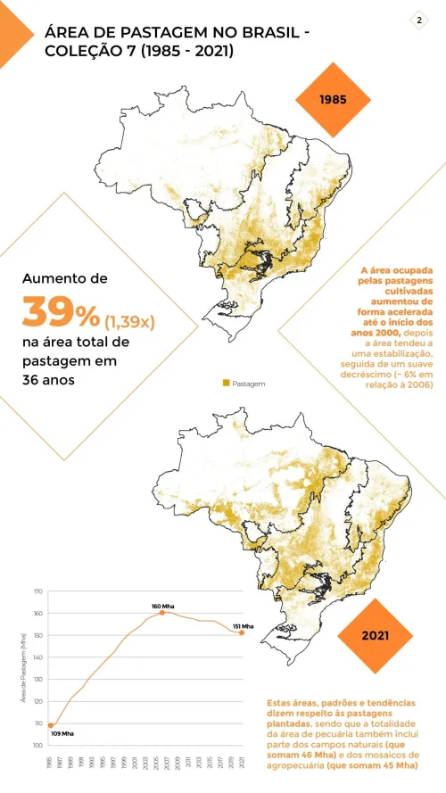
Amazônia É O Bioma Com Maior Área De Pastagens No Brasil

Amazônia É O Bioma Com Maior Área De Pastagens No Brasil

Os dados fazem parte de um mapeamento inédito do MapBiomas que será apresentado em 30 de novembro, pelo YouTube. Ele revela que o principal uso dado ao solo brasileiro continua sendo a pastagem: de toda a área desmatada no Brasil, que já se aproxima dos 35% do território nacional, aproximadamente 90% foram ou continuam sendo ...
ecodebate.com.br
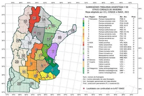
Un Mapa Digital Para Potenciar El Trigo Y Otros Cereales Invernales

Un Mapa Digital Para Potenciar El Trigo Y Otros Cereales Invernales

El trigo es uno de los tres granos más importantes a nivel mundial. En la Argentina, cada año se cultivan entre 5 y 6 millones de hectáreas, cuya producción se exporta sobre todo a Brasil, Perú y Bolivia, y también a países fuera de la región como Turquía y Marruecos. En este contexto, resulta indispensable ...
agrositio.com.ar

UK Launches New Geospatial Data Projects

The UK’s Geospatial Commission has launched a series of projects to explore key land use pressures, such as energy, housing and decarbonisation, and how innovative data analysis can support better decisions about land use change. Through the National Land Data Programme, the Geospatial Commission is convening regional pilots, national roundtables and expert workshops to bring ...
spatialsource.com.au
El CDR Crea El Primer Mapa De Cultivos Abandonados Con El Uso De Imágenes De Satélite

El CDR Crea El Primer Mapa De Cultivos Abandonados Con El Uso De Imágenes De Satélite

Quantify the abandonment of agricultural land using images from the Sentinel-2 satellite. This is the latest study completed by the Centre de Desenvolupament Rural de la Safor and will be presented in the coming weeks. A research included in the Copernicus program of the European Commission and that has allowed to evaluate the figures and ...
cadenaser.com

Satellites Capture Illegal Land Clearing In Australia

Images taken from the European Space Agency’s Copernicus Sentinel-2 mission have resulted in an Australian local government organization being fined for illegal clearing and breaching environmental protection laws. The Shire of Lake Grace council in Western Australia was fined AUD75,000 after being found guilty of unauthorized clearing of native vegetation and was also ordered to ...
cdotrends.com

Land Analysis In Turkey And Bulgaria To Contribute To Ecological Efforts

A research project conducted at Koç University aims to shed light on future social and environmental threats. The study of 30,000 km2 of land in Turkey and Bulgaria will analyze radical changes in land use and land cover. Correlating the data with population dynamics, the research will contribute to predictions of possible agricultural population loss ...
sciencex.com

3D Digital Mapping Via The NSW Planning Portal

NSW’s DCS Spatial Services latest planning system update has seen the enabling of 3D digital mapping for subdivision and strata plans through the NSW Planning Portal. The digitisation of subdivision and strata-related land developments is intended to transform how applicants and assessing authorities visualise applications via the Portal. “Thanks to the work in connecting subdivision ...
spatialsource.com.au

Jak Zmieniała Się Zabudowa Warszawy Tym Razem Na Modelu 3D

Firma GIS-Expert opublikowała animację pokazującą rozwój istniejącej zabudowy w Warszawie w latach 1945–2020 na modelu 3D. To nie pierwsza prezentacja GIS-Expert na temat rozwoju zabudowy miast. Jak już informowaliśmy na Geoforum.pl, kilka lat temu firma opracowała aplikację prezentującą rozwój zabudowy Lublina, która cieszyła się sporym zainteresowaniem i zdobyła tytuł internetowej mapy roku 2016/2017. Wspólnie z ...
geoforum.pl

ITACYL Desarrollará El Primer Mapa Nacional De Alto Detalle De Cultivos

El Instituto Tecnológico Agrario de Castilla y León (ITACYL) se encargará de la encomienda del Ministerio de Agricultura, Pesca y Alimentació de desarrollar el primer mapa nacional de alto detalle de cultivos, a partir de imágenes de satélite, para disponer en 2023 de una primera cartografía de ocupación del suelo agrícola. En rueda de prensa ...
interempresas.net

Ocena Potencjału Obszarów Wiejskich Na Dolnośląskim Geoportalu

Na Geoportalu Dolny Śląsk Ukazała Się Nowa Mapa „Ocena Potencjału Obszarów Wiejskich”. Została Ona Opracowana Na Podstawie Wyników Zawartych W Raporcie Końcowym Projektu „Ocena Potencjału Obszarów Wiejskich Do Rozwoju Funkcji Rolniczo-leśnej, Przyrodniczo-krajobrazowej, Turystyczno-rekreacyjnej, Rezydencjalno-mieszkaniowej I Społeczno-kulturowej” Sporządzonego W 2018 Roku Przez Instytut Geografii I Przestrzennego Zagospodarowania PAN.
geoforum.pl
Informing Future Conservation Priorities For Ecosystems In The Tropical Andes

Informing Future Conservation Priorities For Ecosystems In The Tropical Andes

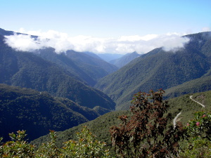
To effectively conserve ecosystems, scientists document and monitor their extent (mapped areas where they occur) and conservation status over time. Combining trends in extent with degree of protection helps to accurately assess the effectiveness of conservation actions. This is what an international research team led by NatureServe and iDiv has illustrated for conservation planning in ...
phys.org
The Impacts Of Climate Change, Population Growth And Land-use Change On Protected Areas In Africa

The Impacts Of Climate Change, Population Growth And Land-use Change On Protected Areas In Africa

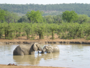
Ph.D. student Carola Martens together with other researchers from Senckenberg and South Africa’s Stellenbosch University has investigated how climate change could affect vegetation in protected areas in Africa. In their study, which was published in the journal Conservation Biology, the team shows where these effects may coincide with population growth and land use changes. According ...
phys.org
Datasets Reveal Impacts Of Land Use And Cover Change On The Sahel-Sudano-Guinean Region In Africa

Datasets Reveal Impacts Of Land Use And Cover Change On The Sahel-Sudano-Guinean Region In Africa

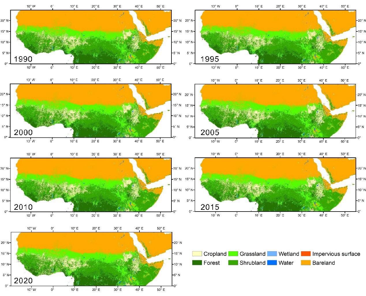
The Sahel-Sudano-Guinean region has been experiencing significant land use and land cover change in the last decades due to climatic and anthropic impacts. A better understanding of these changes is essential for sustainable land and water management in the region. Four datasets on the Sahel-Sudano-Guinean region of Africa have been recently released on the platform ...
phys.org