Geomaticians

Biogeography

This UC Doctoral Student Is Helping Pileated Woodpeckers Find Space In Hamilton County

This UC Doctoral Student Is Helping Pileated Woodpeckers Find Space In Hamilton County

As cities continue expanding, forested areas are becoming scarcer, and less dense. That’s bad news for the wildlife that call those areas home. A University of Cincinnati doctoral student is studying what local areas are important to North America’s largest woodpecker. “The pileated woodpecker is not considered as a vulnerable species, but it is an ...
wvxu.org

Drones To Tally Canines

The Bruhat Bengaluru Mahanagara Palike (BBMP) is contemplating using drones to aid the upcoming dog census in the city. According to the officials, the technology is being actively considered as it will help cover a larger area in a short period and will give a better understanding of the stray population. “Property surveys in the ...
bangaloremirror.indiatimes.com
Scientists Use NASA Satellite Data To Determine Belize Coral Reef Risk

Scientists Use NASA Satellite Data To Determine Belize Coral Reef Risk

Using two decades of NASA satellite measurements stored in the cloud, scientists recently assessed the vulnerability of Belize’s renowned coral reefs to bleaching and collapse. The findings could help management authorities protect the reefs from human impacts such as development, overfishing, pollution, and climate change. In a study published in Frontiers in Remote Sensing, the ...
climate.nasa.gov
Observing Group-living Animals With Drones And Computer Vision

Observing Group-living Animals With Drones And Computer Vision

To explore animal groups such as zebras or gelada monkeys, Ben Koger, Blair Costelloe, Iain Couzin, and other researchers from the Max Planck Institute of Animal Behavior, the CASCB at the University of Konstanz, and Aarhus University developed a new method for collecting data about animal behaviour and the animals’ surrounding natural physical landscape using ...
국립공원 보전관리 업무에 국토위성영상 활용

국립공원 보전관리 업무에 국토위성영상 활용

국립공원공단(공단)과 국토지리정보원(정보원)은 21일, 공단 본사(강원 원주시)에서 국립공원 보전‧관리 강화를 위한 공간정보 협력확대를 목적으로 업무협약을 체결했다. 이번 업무협약은 국가 보호지역의 보전․관리에 있어 국가공간정보 활용성 제고를 위해 추진되었으며, 협약식에는 공단 송형근 이사장과 정보원 조우석 원장이 참석했다. 공단은 정보원에서 제공하는 국토위성 1호가 촬영한 위성영상 등 고품질의 공간정보를 자연자원조사, 재난위험 안전관리, 기후위기 대응 등을 위해 공단에서 추진 중인 각종 ...
sentv.co.kr
National Forest Maps Of Germany Based On Current Satellite Imagery And Terrestrial Data

National Forest Maps Of Germany Based On Current Satellite Imagery And Terrestrial Data

The Thünen Institute now offers interactive forest maps through the Thünen Atlas (http://atlas.thuenen.de) that provide a nationwide overview of the stocked forest area—i.e., the area on which trees grow—and the dominant tree species. The digital maps have a resolution of 10m x 10m. The map of dominant tree species is based on data from the ...
phys.org
Invasive Plant Species Will Spread Even Further In Germany According To Simulation Study

Invasive Plant Species Will Spread Even Further In Germany According To Simulation Study

Many invasive plant species have not yet filled their potentially suitable habitat. This is what geographers at Leipzig University established in a recent simulation study. They coupled different data sets to predict the probability of occurrence of selected invasive plant species for any location in Germany. “Using satellite imagery to divide Germany into quadrants, I ...
phys.org
Scientists Want Help Finding These ‘Jesus’ Lizards

Scientists Want Help Finding These ‘Jesus’ Lizards

Wildlife specialists with the UF Institute of Food and Agricultural Sciences (UF/IFAS) depend on geographic information to determine this lizard’s potential impacts on the environment, wildlife, and human health. They need more information to stay ahead. “We receive anecdotal reports of brown basilisks in areas where the reported sightings are thin and sporadic, but we ...
futurity.org
Google Lança Plataforma Que Prevê A Proliferação De Mosquitos Por Região Do País

Google Lança Plataforma Que Prevê A Proliferação De Mosquitos Por Região Do País

A plataforma “OFF!Cast Previsão de Mosquitos” já está no ar e mostra quais as chances de uma região no país ter maior ou menor presença de mosquitos. A ideia é prevenir a proliferação desses vetores, que trazem doenças como dengue, febre amarela, zika, malária e chikungunya. A OFF!Cast Previsão de Mosquitos é resultado de uma ...
olhardigital.com.br
Sharks, Spatial Data, And A Conservation Success Story

Sharks, Spatial Data, And A Conservation Success Story

It’s hard out there for a shark. A critical barometer to the health of ocean ecosystems, shark and ray populations have faced significant global declines from overfishing, habitat loss, and environment degradation. Add to the mix a slow reproductive cycle and the broader logistical challenges of trying to monitor animals with ranges that can exceed ...
phys.org
Tweets Provide Insights On How Invasive Insects Sprea

Tweets Provide Insights On How Invasive Insects Spread

A new study led by North Carolina State University has found that Twitter and online new articles could be used effectively to track the timing and location of invasive insect spread in the United States and globally. These findings suggest that such sources are promising for filling gaps when official data are not widely available. ...
earth.com
Ecologistas En Acción De La Rioja Confecciona Un Mapa Topográfico Educativo Sobre Los Hábitats Naturales De Calahorra

Ecologistas En Acción De La Rioja Confecciona Un Mapa Topográfico Educativo Sobre Los Hábitats Naturales De Calahorra

Ecologistas en acción de La Rioja, ha presentado al Ayuntamiento de Calahorra un nuevo mapa sobre hábitats naturales del término municipal , un trabajo que bajo la dirección del biólogo Gabriel Furgiuele, se ha venido realizando en los últimos meses por el colectivo ambientalista , delimitando todos los hábitats naturales que se dan cita en ...
europapress.es
서울대-국민대 연구진, 외래생물 위치정보 추적 시스템 개발

서울대-국민대 연구진, 외래생물 위치정보 추적 시스템 개발

이에 따라 외래생물의 위치를 추적할 수 있는 위치정보 시스템, 실시간 지도화가 가능한 공간정보 플랫폼, 수집된 정보의 과학적 분석을 통한 대상 종의 생태성 이해와 우선 대응지역 도출, 이 모든 과정을 보다 쉽게 활용할 수 있는 매뉴얼이 요구된다. 특히 기존 위치추적 장치들은 주로 해외 제조사 제품들로, 자료의 보안성과 신뢰성, 송수신 음영지역, 안정성과 내구성, 기술지원 및 비용 등의 ...
lafent.com
Pampa Sul-americano Perde Um Quinto Da Vegetação Campestre Entre 1985 E 2021

Pampa Sul-americano Perde Um Quinto Da Vegetação Campestre Entre 1985 E 2021

A análise de imagens de satélite captadas entre 1985 e 2021 por uma rede colaborativa de especialistas da Argentina, Brasil e Uruguai, sob coordenação do MapBiomas, mostra que o Pampa Sul-Americano perdeu 20% de sua vegetação campestre no período, incluindo 8,7 milhões de hectares de campos nativos e 260 mil hectares de florestas. Os dados ...
extraclasse.org.br
Airbus Foundation Looks To Put Satellites To New Biodiversity Conservation Uses

Airbus Foundation Looks To Put Satellites To New Biodiversity Conservation Uses

The Airbus Foundation and the Connected Conservation Foundation (CCF) recently announced a new award for research that would use satellites to aid in biodiversity conservation. The application period, open to individual researchers and nonprofit organizations, began Dec. 5 and ends Feb. 3, 2023. A team of four judges will assess the potential of proposals designed ...
news.mongabay.com

Catawba College’s Jacobson Co-authors Study On Wilderness Areas

The expansion of agriculture to feed a growing global population of more than 8 billion people will shrink the world’s remaining wilderness areas by the end of the century, according to projections reported in a new study published this month in the peer-reviewed, scientific journal “Biological Conservation.” Andrew Jacobson, an assistant professor at Catawba College, ...
salisburypost.com
El Principado Publica Una Recopilación De Datos Cartográficos Sobre Espacios Naturales Y Animales Silvestres

El Principado Publica Una Recopilación De Datos Cartográficos Sobre Espacios Naturales Y Animales Silvestres

La Consejería de Medio Rural y Cohesión Territorial ha publicado la mayor recopilación divulgada hasta ahora de datos cartográficos sobre los espacios naturales protegidos que integran la Red Natural de Asturias (RENA) y los animales silvestres que los habitan, un trabajo que permitirá mejorar su conocimiento y gestión. La información incluye más de 15.000 referencias ...
europapress.es
Japan Launches Project To Map 90% Of Coastal Waters

Japan Launches Project To Map 90% Of Coastal Waters

The ‘Umi-no-Chizu’ (‘Map of the Sea’) project will use aerial measurement to map 90% of Japan’s shallow coastal waters (to a depth of 20m). This is a joint project by the Japan Hydrographic Association (JHA) and The Nippon Foundation. Regulatory, administrative management and jurisdiction issues have meant that less than roughly 2% of Japan’s coastal ...
gim-international.com
Web Mapping To Support The National Forest’s 25-year Vision

Web Mapping To Support The National Forest’s 25-year Vision

The National Forest Company (NFC) has awarded Cadcorp the contract to provide Cadcorp SIS Desktop, and cloud hosted Cadcorp SIS WebMap and Cadcorp Spatial Database Service. The contract includes a variety of services such as application management, support, and training. The National Forest covers 200 square miles of the Midlands. Since 1995, over 9 million ...
directionsmag.com
Esri UK Provides Mapping Expertise For DfE’s Major New Climate Project

Esri UK Provides Mapping Expertise For DfE’s Major New Climate Project

The Department for Education (DfE) has released further details of its National Education Nature Park, created to teach children of all ages about climate change and improve biodiversity across the country. Esri UK is providing a digital mapping platform and expertise in biodiversity mapping to help underpin this exciting initiative, first announced at COP26 by ...
geospatialworld.net

UN Biodiversity Lab Is Now A Registered Digital Public Good

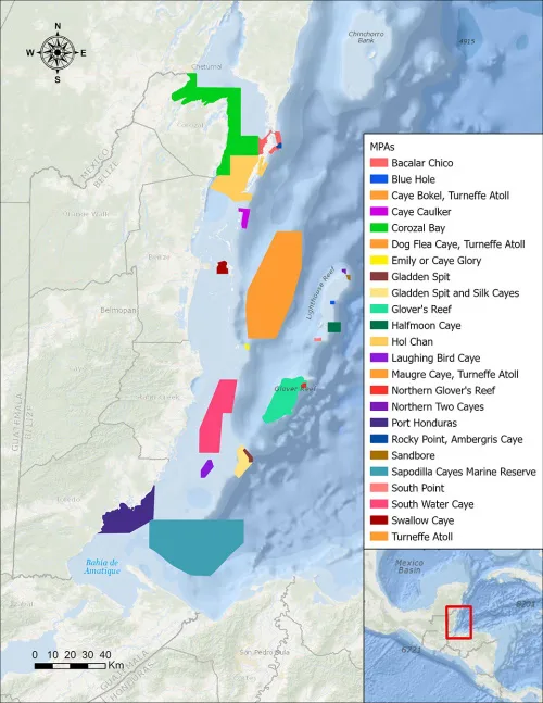
The UN Biodiversity Lab (UNBL), an innovative spatial data analytics platform supported by One Earth, is now a digital public good, facilitating open access to spatial data that can inform environmental evidence-based decisions. Designed to aid policymakers in identifying and addressing pressing issues related to conservation and sustainable development, UNBL is a key resource available ...
oneearth.org
NASA, USGS Map Minerals To Understand Earth Makeup, Climate Change

NASA, USGS Map Minerals To Understand Earth Makeup, Climate Change

NASA and the U.S. Geological Survey (USGS) will map portions of the southwest United States for critical minerals using advanced airborne imaging. Hyperspectral data from hundreds of wavelengths of reflected light can provide new information about Earth’s surface and atmosphere to help scientists understand Earth’s geology and biology, as well as the effects of climate ...
nasa.gov
Presentan Un Mapa Online Que Identifica Los Humedales De La Argentina

Presentan Un Mapa Online Que Identifica Los Humedales De La Argentina

Con la participación de más de 30 especialistas del INTA de todo el país, se generó un mapa nacional de humedales. Se trata de una herramienta técnica, con información actualizada y precisa, disponible en una plataforma online, de acceso libre y gratuito. Un desarrollo clave para la toma de decisiones en relación con estos socio-agroecosistemas. ...
intainforma.inta.gob.ar
Monitoring Forest Threats With New Open Forest Observatory

Monitoring Forest Threats With New Open Forest Observatory

Environmental managers will have a powerful new resource for helping our forests survive and recover from wildfire, drought and disease. UC Davis ecologist Derek Young is leading a team to develop the Open Forest Observatory, a pioneering project combining drone photography and forest mapping with machine learning, remote sensing, big-data crunching and open information sourcing. ...
ucdavis.edu
Moradores Poderão Usar O Celular Para Cadastrar As Árvores Da Serra

Moradores Poderão Usar O Celular Para Cadastrar As Árvores Da Serra

A população da Serra vai ajudar a prefeitura a catalogar as árvores localizadas na zona urbana do município. Por meio do celular, cidadãos em geral poderão fotografar, identificar e registrar a localização das árvores, colaborando para a criação do banco de informações que vai servir de base para o Plano Diretor de Arborização Urbana do ...
eshoje.com.br
Assessing Global Biodiversity With Ears To The Ground, NASA Eyes In The Sky

Assessing Global Biodiversity With Ears To The Ground, NASA Eyes In The Sky

Purdue University professor Bryan Pijanowski’s research team will be working in some wild and remote places around the globe in the coming year. Pijanowski’s sound-source surveyors will be equipped with microphones, headphones and parabolic reflectors to efficiently collect sound waves from the natural world. Their tools also include low-flying drones and sensors mounted on orbiting ...
purdue.edu

First-of-its-kind Digital Platform Reveals Migration Data For Birds Across The Western Hemisphere Just In Time For Fall Migration

As millions of birds are flocking to their wintering grounds, the Smithsonian Migratory Bird Center and nine partner organizations announced today the Bird Migration Explorer, a state-of-the-art digital platform that reveals migration data consolidated for 458 bird species found in the United States and Canada. The free, interactive platform, available in English and Spanish, allows ...
nationalzoo.si.edu