Geomaticians

Digital Twin

Una Recreación Virtual De Galicia Permitirá Gestionar Datos Del Territorio Y Hacer Predicciones Y Simulaciones Con Inteligencia Artificial

Una Recreación Virtual De Galicia Permitirá Gestionar Datos Del Territorio Y Hacer Predicciones Y Simulaciones Con Inteligencia Artificial

Una recreación virtual de Galicia sobre una base cartográfica, datos reales procedentes de sensores y otras fuentes permitirá a las administraciones y empresas realizar simulaciones y pruebas y mejorar la prestación de servicios con el uso de tecnologías de Inteligencia artificial. La Axencia para a Modernización Tecnolóxica de Galicia, de la Consellería de Facenda e ...
xunta.gal
Esri's GIS Helps Vodafone Create National Digital Twin

Esri’s GIS Helps Vodafone Create National Digital Twin

Vodafone has created a 3D digital twin of its UK mobile mast network to allow its engineers to visualise and strategise network improvements or expansion. It will allow them to make instant decisions to improve services to customers without leaving their desks. The digital twin involved mapping more than 40 million environmental features using advanced ...
directionsmag.com
Cantabria Crea Su Propio Gemelo Digital

Cantabria Crea Su Propio Gemelo Digital

Cantabria ya tiene un gemelo digital. El gobierno autónomo ha creado una réplica virtual de las 533.000 hectáreas que componen la comunidad, en el que se puede ver en 3D todo su territorio y edificios. En una alianza con el Centro Nacional de Información Geográfica (CNIG), el Gobierno de Cantabria ha creado uno de los ...
ciospain.es

NGIS And Google Earth Engine Work On Digital Twin

NGIS has collaborated with a range of organisations on the Australian Environmental Health (AusEnHealth) Strategic Planning Digital Twin project. The project aims to understand the landscape of environmental health data collection around the country. By 2030, the direct damage of costs to health is expected to be between $3 billion and $6 billion per year, ...
spatialsource.com.au

Hexagon And Fujitsu Support Stuttgart Urban Digital Twin Project

Hexagon’s Safety, Infrastructure & Geospatial division and Fujitsu Limited have partnered to deliver a digital twin platform for Stuttgart, Germany, to support the city’s urban digital twin project. The Civil Engineering Office will use the SaaS solution to visualize and analyse data from IoT sensors across the city to promote sustainability and enhance quality of ...
gim-international.com
Norway’s Answer To The Smart City Is A “Smart Forest”

Norway’s Answer To The Smart City Is A “Smart Forest”

Norwegian scientists are using mobile lidar to see how individual trees are connected with each other, to help innovate its forest sector and realize efficiency gains. Led by The Norwegian Institute of Bioeconomy Research (NIBIO), the SFI SmartForest aims to bring industry 4.0 to the sector over an 8-year period. Focusing on silviculture, forest operations, ...
geoweeknews.com

Isparta’nın Dijital Ikiz Uygulaması Hazır

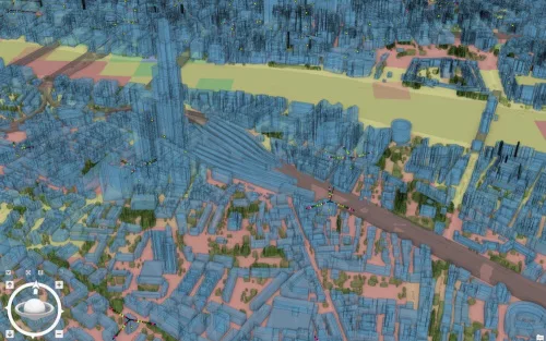
Çevre, Şehircilik ve İklim Değişikliği Bakanlığı Coğrafi Bilgi Sistemleri Genel Müdür Yardımcısı Akın Kısa vebakanlık yetkilileri Isparta Belediye Başkanı Şükrü Başdeğirmen’i makamında ziyaret etti. Ziyarete İl Müdürü Abdullah Borcada eşlik ederken, görüşmede Isparta’nın Dijital İkiz Uygulaması değerlendirildi. Kentsel Yerleşim ve Gelişme Alanlarında 3 Boyutlu Topoğrafya ve Bina Modeli Oluşturma Projesi ile Isparta’nın havadan çekilen fotoğraflarıyla ...
son32.com

Presagis Launches Cloud-based VELOCITY 5D Digital Twin Production Platform

Presagis, a global leader in 3D advanced modelling and simulation software, has officially launched its VELOCITY 5D (V5D) cloud-based platform that quickly and automatically converts massive volumes of 2D geospatial data into high-fidelity 3D digital twins. V5D leverages artificial intelligence and game engine technology to run complex visualization and simulation scenarios that derive context from ...
financialpost.com

서울시, 초실감형 디지털 3차원 지도 서비스 첫 선

서울시는 가보지 않아도 현장을 생생하게 느낄 수 있는 초실감형 디지털 3차원 지도 서비스를 2일 스마트국토엑스포에서 시범 공개한다고 1일 밝혔다. 시는 이번 사업으로 실감형 디지털 트윈 구축 기술을 보유한 모빌테크, 티랩스와 업무 협약을 체결하고, 초실감형 서비스 개발 등 다양한 공간정보 과제 해결에 힘쓰고 있다. 사는 향후 S-Map 홈페이지를 통해서 누구나 초실감형 디지털 트윈을 체험할 수 있도록 ...
pmnews.co.kr

OHLA Presenta Una Representación Virtual De Una De Sus Obras Ferroviarias En Suecia

Grupo OHLA presentará en la Conferencia Esri, que se celebra el próximo 19 de octubre en Ifema Madrid, el gemelo digital de un contrato que ha llevado a cabo en Suecia para la construcción de una de las principales líneas ferroviarias del país. “El proyecto es un ejemplo innovador a nivel europeo por el uso ...
negocios.com
Il Modello Digitale Di Palazzo Pitti È Pronto

Il Modello Digitale Di Palazzo Pitti È Pronto

Se n’era cominciato a parlare un anno e mezzo fa, del progetto dedicato ai grandi edifici storici nell’era della transizione tecnologica. Oggi gli Uffizi presentano il gemello digitale del più grande edificio storico civile fiorentino, ed è la prima volta che un complesso antico così vasto e articolato viene integralmente riprodotto ad altissima definizione, “fedele ...
insideart.eu
The Digital Twin Victoria Platform Goes Live

The Digital Twin Victoria Platform Goes Live

The eagerly anticipated Digital Twin Victoria (DTV) platform is now live, following completion of its first development phase. The digital replica of the state is being built in partnership with Australia’s National Science Agency CSIRO. The platform is just one piece of the DTV program, a $37.4 million investment by the Victorian Government in digital ...
spatialsource.com.au
KT-이지스, 3D 디지털 트윈 플랫폼 서비스 구축 협력

KT-이지스, 3D 디지털 트윈 플랫폼 서비스 구축 협력

KT 는 이지스와 3D 지도·공간정보를 바탕으로 일조권 변화·침수 예측 등 모의시험이 가능한 ‘디지털 트윈 플랫폼 서비스’를 공동 구축하는 데 협력하는 업무협약(MOU)을 맺었다고 26일 밝혔다. KT는 자사 클라우드 게임서비스 ‘게임박스’에 쓰이는 차세대 게임스트리밍 솔루션으로 디지털 트윈 플랫폼을 제공하고 있다. 디지털트윈은 현실의 사물이나 시스템 등을 가상공간에 같은 크기로 만들어 시뮬레이션하는 기술이다. 이지스는 자체 지리정보시스템(GIS) 엔진 기술로 3D ...
vip.mk.co.kr

Denizli’nin Gelişimi Dron Ile Havadan Takip Edilecek Denizli’de Dijital Şehir İkiz Projesi Çekimleri Başladı

Çevre, Şehircilik ve İklim Değişikliği Bakanlığı Coğrafi Bilgi Sistemleri Genel Müdürlüğü tarafından başlatılan “Dijital Şehir İkizleri3 Boyutlu Model Oluşturma” çalışmaları, pilot illerden biri olan Denizli’de de başladı.
haberturk.com